The Great Longitude Mystery
D Vautier
5/2019
 When
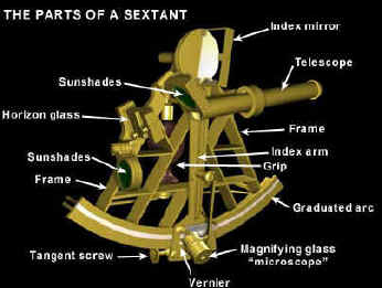
I was 12 years old I built my first sextant. The base was plywood in a triangular shape rounded at the bottom,
nothing near as classy as the picture.
There was an arm that traversed the base and it had a little
indicator wire. I ordered
front surface mirrors and filters and all the other odds-and-ends parts from
various scientific hobby shops like Lafayette, Esco Products,
Radio
Shack and others that advertised in Sky and Telescope Magazine.
My front surface mirror was mounted permanently to the arm axis
and the see-through mirror was mounted midway on the body. A peep hole eyepiece was set up in the back.
I arranged a number of sun filters to fit in front of the main
mirror.
When
I was 12 years old I built my first sextant. The base was plywood in a triangular shape rounded at the bottom,
nothing near as classy as the picture.
There was an arm that traversed the base and it had a little
indicator wire. I ordered
front surface mirrors and filters and all the other odds-and-ends parts from
various scientific hobby shops like Lafayette, Esco Products,
Radio
Shack and others that advertised in Sky and Telescope Magazine.
My front surface mirror was mounted permanently to the arm axis
and the see-through mirror was mounted midway on the body. A peep hole eyepiece was set up in the back.
I arranged a number of sun filters to fit in front of the main
mirror.
I
had a little trouble setting up a graduated scale to calibrate my sextant.
Using a long string I arranged three equidistant poles in a field
and placed the sextant on its side on one pole bringing the two other
poles into overlap. There
was my 60 degrees from geometry. I then did a Pythagorean calculation on a length of the string
and moved one stick to form a 90 degree triangle. With these measurements and a bunch of others I was able to build a graduated
scale and glued it to the bottom of my sextant.
We
lived in a place where there was no horizon so I made an artificial
horizon, which is merely the reflection of the sun from a pan of water.
The reflection was half the distance.
I
began shooting the sun. I knew that Everett, Wa. was several degrees past our standard time
meridian. Consulting the equation-of-time I calculated
that the sum would reach
my local time meridian a little late that time of year. On several days I took sun shots and tried to
mark the angle
every minute. Eventually I
arrived at a latitude that was about one mile off and a longitude that was
7 miles off to the west right in the middle of Gardner Bay
near
Hat Island. I considered this project
finished and forgot all about it and moved on to other more interesting
things. After all I was only 12.
 But
70 years later it is fascinating to think about just what I had been
able to do because of all the incredible amount of technology that has
been developed over a long time
to support these simple efforts.
But
70 years later it is fascinating to think about just what I had been
able to do because of all the incredible amount of technology that has
been developed over a long time
to support these simple efforts.
Sources used:
Bown,
Stephen R., Madness
Betrayal and the Lash,
2008)
Bruton, Eric (the
history of clocks, Orbis Publishing, 1979)
Jenkins, Martin (the time book,
Martin Jenkins, 2009)
Cronin, John (the Marine
Chronometer, Crowood Press, 2017)
Milham, Willis (Time & Time
Keepers, Macmillan, 1923)
Sobel, Dava (Longitude,
Walker, 1995)
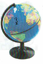 So what did I just do?
I
found my latitude and longitude and it was pretty easy. Briefly
here's how it was all done. But before any part of this
simple procedure was developed many other things had to be figured out, such as
how to construct a grid over the surface of the earth and who would do
it and how it would be designed. If nobody moved anywhere there
would be no need for maps, but mankind had a habit of moving constantly all over the planet.
Location became more and more critical especially for ships during the age of
discovery (1500 to 1800).
So what did I just do?
I
found my latitude and longitude and it was pretty easy. Briefly
here's how it was all done. But before any part of this
simple procedure was developed many other things had to be figured out, such as
how to construct a grid over the surface of the earth and who would do
it and how it would be designed. If nobody moved anywhere there
would be no need for maps, but mankind had a habit of moving constantly all over the planet.
Location became more and more critical especially for ships during the age of
discovery (1500 to 1800).
This
all happened before GPS which we now casually take for granted but even
GPS is based on a huge amount of science which was built up over a long
period of time.
The
first and foremost difficulty confronting navigation was the development
of timekeeping, and even before accurate time could be considered a good calendar
was needed. A
calendar involved much more than just counting days as discussed here
but it involved an intricate knowledge of
how the planet worked with the sun and understanding the movements. A lot more science still was needed and in order to navigate the planet
but having an
accurate calendar was certainly the first step.
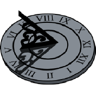 Keeping
rough day to day
time was easy by just observing the sun using sundials.
But the problems of navigation at sea presented a need for
accurate timekeeping. It is amazing that the first mechanical
clock was invented in 1360 and it was another 400 years before
any portable seaworthy clock was invented.
Keeping
rough day to day
time was easy by just observing the sun using sundials.
But the problems of navigation at sea presented a need for
accurate timekeeping. It is amazing that the first mechanical
clock was invented in 1360 and it was another 400 years before
any portable seaworthy clock was invented.
With
the rise in sea power the nations of Europe had huge fleets and no good
way to map the vast oceans. Thus began the quest for the long sought
after secret of Finding "The Longitude" as
described in this essay.
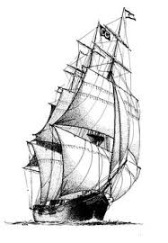 A
sudden increase in ocean going exploration beginning with Dias, Da Gama
and Columbus created all kinds of accidents because of uncharted waters,
poor navigational aids and no sea maps. Even good sailors ran into
shoals and rocks. Raging storms blew ships way off course, and
they became lost in such huge seas. Ships were woefully unprepared
for months at sea where scurvy and other diseases tock their toll.
The five Magellan ships ran out of crew and only 17 sailors returned
with one ship. It was a sad beginning to ocean sailing. Full
oceans were a lot bigger by far then the Mediterranean.
A
sudden increase in ocean going exploration beginning with Dias, Da Gama
and Columbus created all kinds of accidents because of uncharted waters,
poor navigational aids and no sea maps. Even good sailors ran into
shoals and rocks. Raging storms blew ships way off course, and
they became lost in such huge seas. Ships were woefully unprepared
for months at sea where scurvy and other diseases tock their toll.
The five Magellan ships ran out of crew and only 17 sailors returned
with one ship. It was a sad beginning to ocean sailing. Full
oceans were a lot bigger by far then the Mediterranean.
Even though good mariners could sail
the Latitude, "The Longitude"
soon became a number one scientific problem to world navigation.
The
Longitude