The Basics of Global Location
before GPS
D Vautier
6/2019
In order to make any sense of the
following, I need to explain four ideas: local time
meridian, the celestial equator, the equation-of-time, and sun declination.
After that it's all easy to understand everything else.
Local Time Meridian
Draw
a line from pole to pole going through your location. Project that line
into a plane that goes straight up. This is called your local time meridian.
It is quite significant because the instant the sun or a star
crosses that meridian it will help calculate where you are on the
planet. There are telescopes with fixed crosshairs that are on axes that
only allow the telescope to traverse up and down the local time meridian. These are
called meridian circle telescopes (Milham, 6). These were very valuable in
early astronomy because they recorded sidereal time
which is very accurate.
When the sun or
a star crosses your local time meridian it is blazing
along at about a mile a second.
The
local time meridian should not be confused with the standard
time meridian.
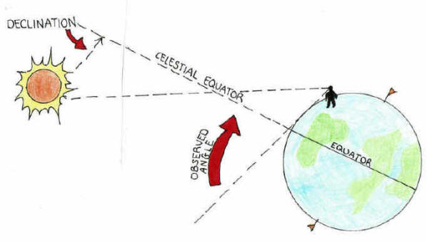
Celestial equator
The
celestial equator is a projection of earth’s equator out into the
heavens, nothing more. This equator moves
as the earth revolves around the sun since the earth is tilted in its
orbit. The sun and stars appear to move above and below the celestial
equator anywhere from 0 to 23.4 degrees.
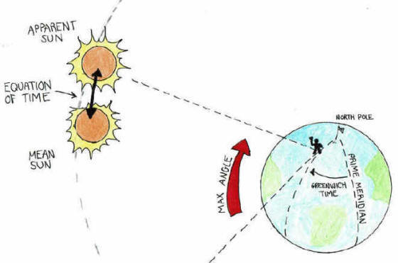
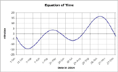
Equation-of-time
It
has been known from antiquity through the use of sundials and astrolabes
that
the sun crosses your local time meridian not quite at noon but sometimes a
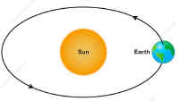
little early or sometimes a little late. This is caused because the
earth’s orbit is an ellipse and the earth moves faster or slower in
its orbit at
different times during the year. As a result the sun may be a
little ahead or behind schedule when it comes overhead
(Milham, 13).
 This
is sometimes called the mean sun, an imaginary spot where the sun
would be if the earth orbit were a perfect circle and the earth traveled
at the same speed all the time.
The equation-of-time adjusts the sun to it's mean position.
This
is sometimes called the mean sun, an imaginary spot where the sun
would be if the earth orbit were a perfect circle and the earth traveled
at the same speed all the time.
The equation-of-time adjusts the sun to it's mean position.
The
earth is closest to the sun in January and farthest from the sun in
early July and moving slower in orbit. Thus the sun is ahead of schedule
February and July and behind schedule in May and October.
Sun Declination
 Since
the earth is tilted 23 degrees in it's orbit the sun wanders above and
below the celestial equator. The
distance in degrees that the sun is above or below this equator
on any specific day is called its declination, an indispensible ingredient
when
determining latitude.
Since
the earth is tilted 23 degrees in it's orbit the sun wanders above and
below the celestial equator. The
distance in degrees that the sun is above or below this equator
on any specific day is called its declination, an indispensible ingredient
when
determining latitude.
Latitude
Since antiquity mariners
have been able to get a fairly good idea of their latitude although instruments were not very precise so their latitude was not either. The
ancients did however have a rough idea of the suns declination. When the sun hit their local time meridian (at its highest point
during the day), the angle of the sun above the horizon at that instant, when adjusted for declination becomes
latitude. With the advent of precision instruments like the sextant, very accurate readings could be achieved.
Longitude
The
very instant that the sun crosses a local time meridian, this time
then becomes longitude after applying the equation-of-time
adjustment as explained above to arrive at a mean sun location.
Equation of time
But for so many years obtaining accurate
Greenwich time was the
big difficulty. The sun moves at around a mile a second over the face of the
earth and a fraction of a second can make a big difference.